

Global Seismic Hazard Map Online Service for hazard map generation and GSHAP data download.
Copies of the printed map are out of stock.
The primary goal of GSHAP was to create a global seismic hazard map in a harmonized and regionally coordinated fashion, based on advanced methods in probabilistic seismic hazard assessments (PSHA).
The GSHAP strategy was to establish Regional Centres which were responsible for the coordination and realization of the four basic elements of modern PSHA:
- Earthquake catalogue
- Earthquake source characterization
- Strong seismic ground motion
- Computation of seismic hazard
The Global Seismic Hazard Map Data
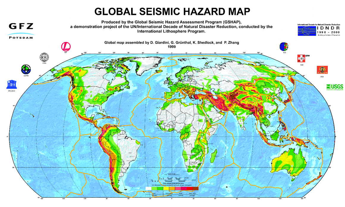
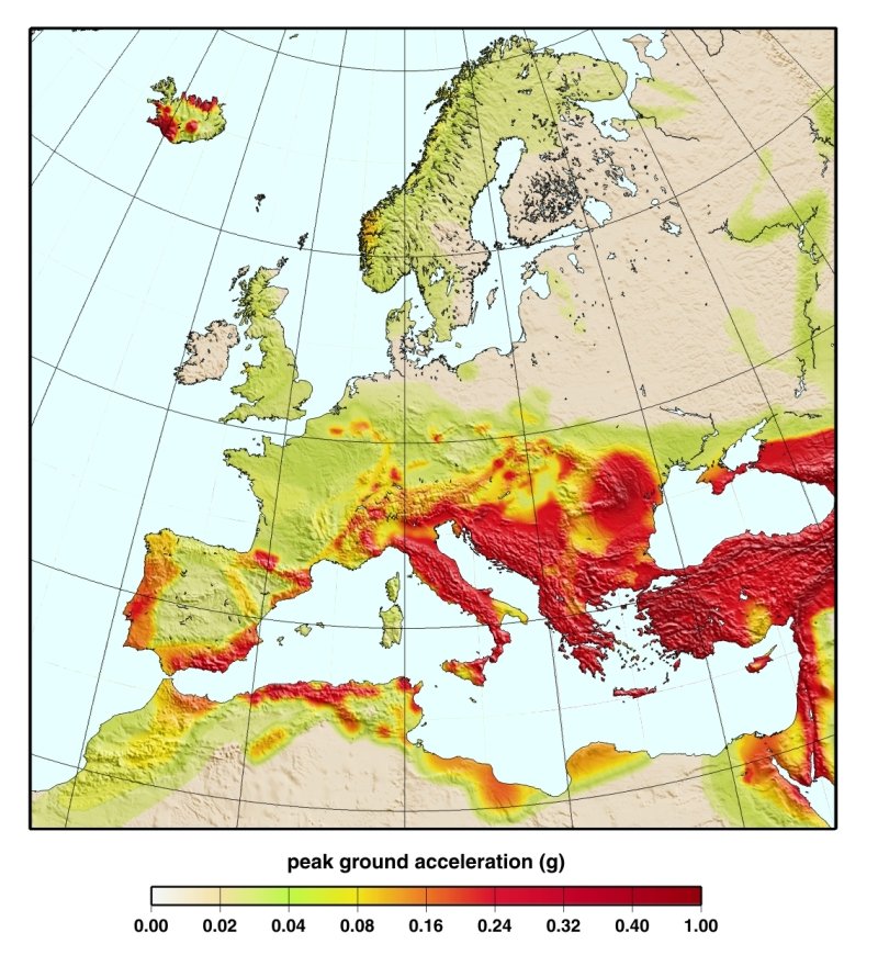
The Global Seismic Hazard Map depicts the seismic hazard as peak ground acceleration (PGA) with 10% probability of exceedence in 50 years, corresponding to a return period of 475 years.
The compilation of the Global Seismic Hazard Map was based on the integration of all results from GSHAP regions and test areas in three greater GSHAP areas.
- the Americas (Shedlock & Tanner, 1999)
- Asia, Australia and Oceania (Zhang et al., 1999; McCue, 1999)
- Europe, Africa and the Middle East (Grünthal et al., 1999)
Seismic Hazard Data
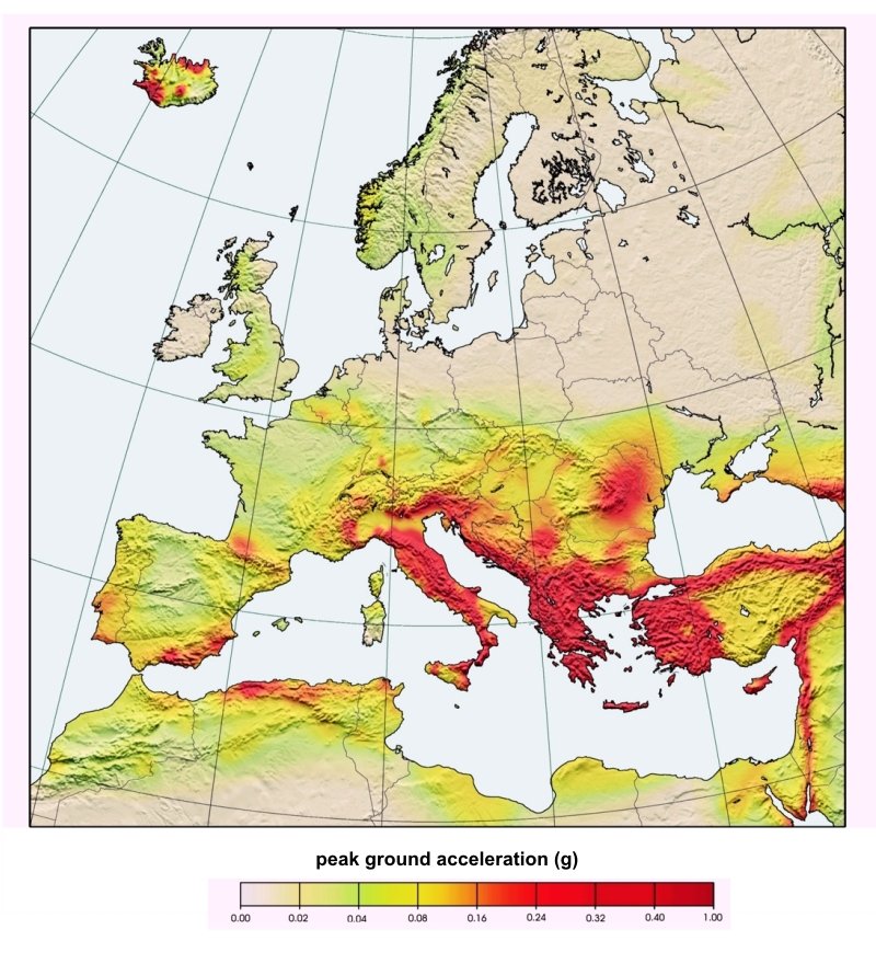
Seismic hazard maps depict the level of chosen ground motions that likely will, or will not, be exceeded in a given time span. Hazard assessment programs commonly specify a 10% chance of exceedence (or a 90% chance of non-exceedence) of a ground motion parameter for an exposure time of 50 years, corresponding to a return period of 475 years. The seismic hazard data describes the peak ground acceleration (PGA, ms-2).
Activities at and Contributions from the GFZ Section 2.6 to the GSHAP World Map
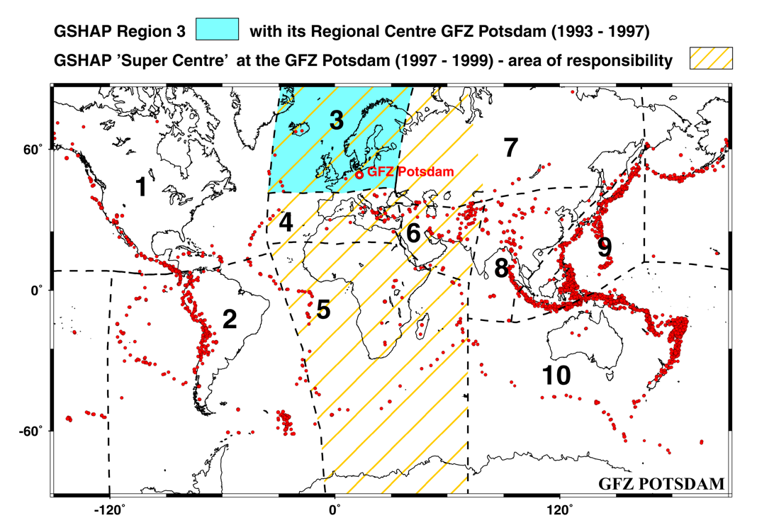
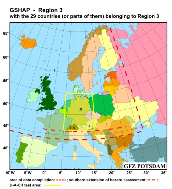
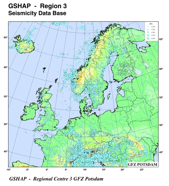
The PSHA research group around G. Grünthal became responsible for the GSHAP Region 3, north of 46°N and west of 32°E, where all basic elements were realized. The countries Germany (D), Austria (A) and Switzerland (CH) (D-A-CH-countries) served as test area for the GSHAP Region 3. Later on within the project, the GSHAP Regional Centre in Potsdam had to take over the responsibilities of the GSHAP Centres 4, 5, and 6.
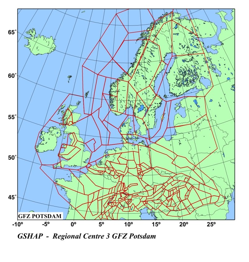
Seimicity Source Regions

Seismic source zones as they were used for seismic hazard assessments in the GSHAP Region 3 as well as in the Mediterranean: Zones used by the GSHAP Regional Centre Potsdam (red), by the Subcentre Barcelona (blue), by the Italian group (dark violet), by the Greek group (yellow), for the Balkans by the BGS Edinburgh (cyan) and for the Caucasus project (black). The full report is given by Grünthal et al. (1999a).

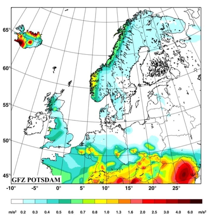
Peak horizontal acceleration map with a 90% probability of non-exceedence within 50 years for Europe, Africa, Near and Middle East; based on results as mentioned in connection with the other figures as well as on peak ground acceleration data for south and east Africa provided by K. Atakan (Bergen) and the remaining parts of Africa by S. Selami (Zurich), and data for Iran by B. Tavakoli (Teheran). The full report is given by Grünthal et al. (1999b).

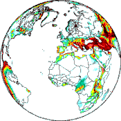
GSHAP-World Map of Seismic Hazard
(Giardini et al., 1999; Shedlock et al., 2000)
Further details see: www.seismo.ethz.ch/GSHAP/index.html
References and literature:
Giardini, D., Grünthal, G., Shedlock, K. M. and Zhang, P. (2003) The GSHAP Global Seismic Hazard Map. In: Lee, W., Kanamori, H., Jennings, P. and Kisslinger, C. (eds.): International Handbook of Earthquake & Engineering Seismology, International Geophysics Series 81 B, Academic Press, Amsterdam, 1233-1239.
Grünthal, G. (2000) Die Weltkarte der Erdbebengefährdung - Ergebnis des globalen Forschungsprogramms zur Abschätzung der seismischen Gefährdung (GSHAP). In: Zweijahresbericht 1998/1999, GeoForschungsZentrum Potsdam, Potsdam, 115-122.
Grünthal, G., Bosse, C., Mayer-Rosa, D., Rüttener, E., Lenhardt, W., Melichar, P. (1995) Across-boundaries seismic hazard maps in the GSHAP-Region 3 - case study for Austria, Germany, and Switzerland. 24th General Assembly, European Seismological Commission (Athens/Greece 1994). Proceedings, Vol. II, 1542-1548.
Grünthal, G. (1994) The GSHAP-Regional Centre in Potsdam: progress report. 24th General Assembly, European Seismological Commission (Athens/Greece 1994). Proceedings and Activity Report 1992-1994, Vol. III, 1535-1541.
