

Finalising Surveys for the Baltic Motorways of the Sea (FAMOS)
GFZ/Section 1.2 was cooperation partner of the EU project FAMOS (Finalising Surveys for the Baltic Motorways of the Sea). Among others, FAMOS included all aspects of hydrographic surveying in the Baltic Sea according to the recommendations of the Baltic Sea Hydrographic Commission (HSHC) and the Baltic Marine Environment Protection Commission (Helsinki Commission – HELCOM).
FAMOS was a joint project of hydrographic, maritime and geodetic institutions and agencies of almost all EU countries around the Baltic Sea. FAMOS was co-funded by the European Commission within the Connecting Europe Facility (CEF Transport). FAMOS aimeds to improve the safety on the motorways of the sea in the Baltics. Part of the FAMOS activities was estimation of a new gravimetric geoid as common and unified chart datum in this sea.
- Project management: Swedish Maritime Administration (Sjöfartsverket)
- Geodetic project partners:
- Deutsches GeoForschungsZentrum GFZ, Bundesamt für Seeschiffahrt und Hydrographie, Federal Agency for Cartography and Geodesy (BKG)
- Technical University of Denmark (DTU Space)
- Lantmäteriet (Schweden)
- National Land Survey of Finnland (NLS)
The FAMOS project started in 2014 und was finalized by 2019. The geoid determination in the FAMOS project was co-funded by the EU Commission with 50% of the costs. The calculation of the new gravimetric geoid (the Baltic Sea Chart Datum 2000) is currently being completed under the direction of the HSHS Chart Datum Working Group.
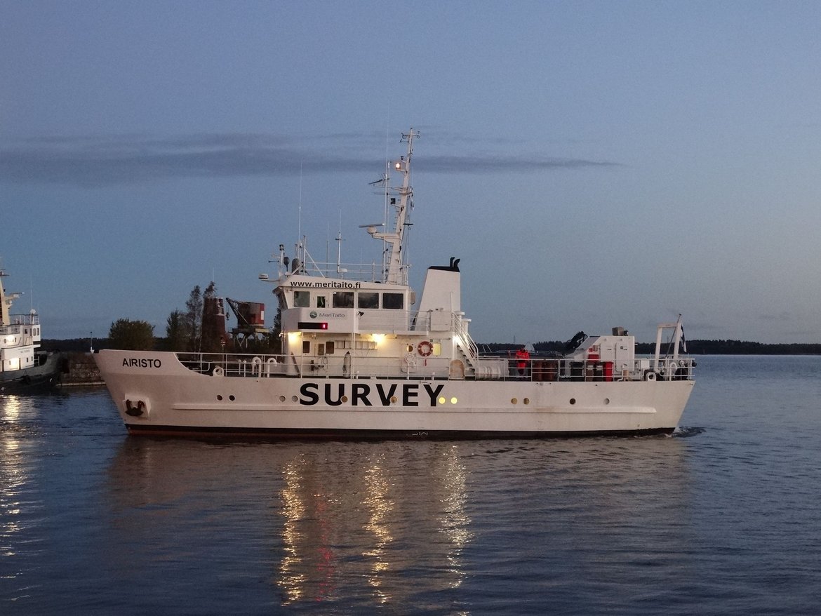
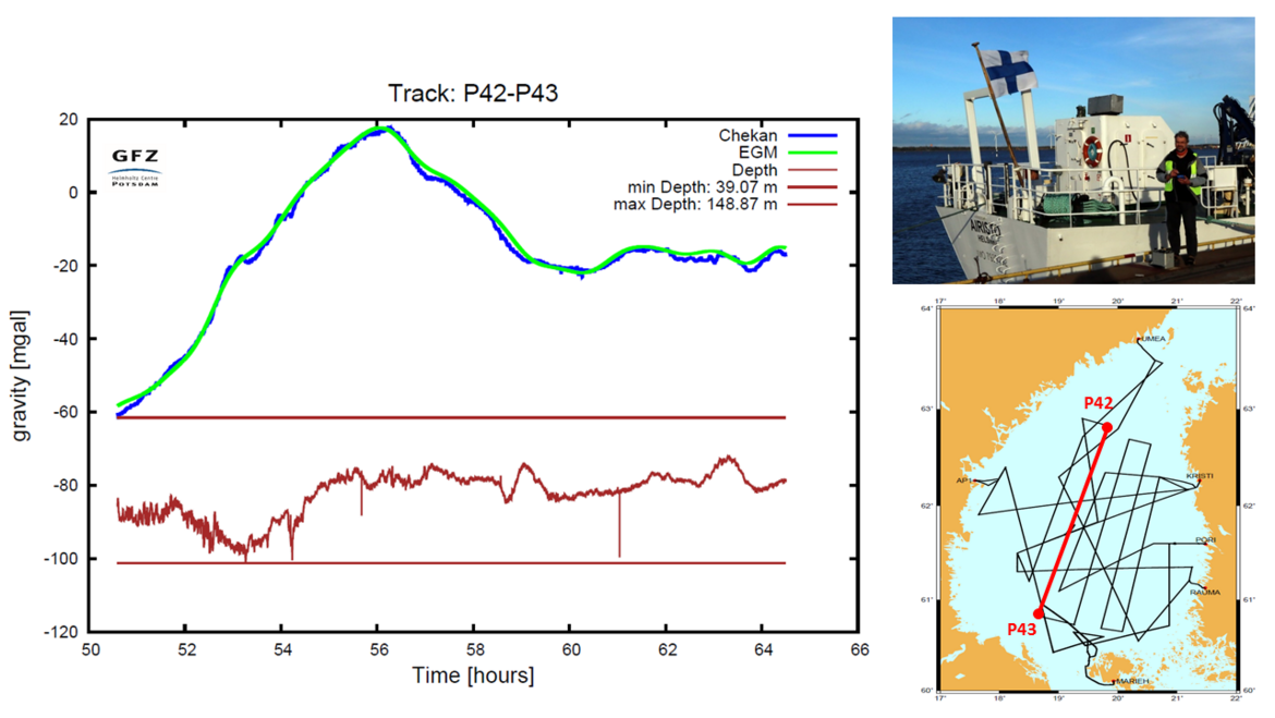
GFZ’s contribution in the FAMOS project was conduction of shipborne gravimetry campaigns including the related data processing. The shipborne gravity measurements for FAMOS were done with the Chekan-AM gravimeter equipment.
ADVANTAGE: Advanced Technologies for Navigation and Geodesy
GFZ Work Packages of Project ADVANTAGE
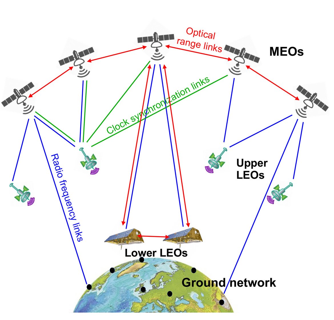
Future generations of European global navigation satellite systems are expected to take advantage of recent breakthroughs in optical clock and optical data communication technology, progressions in atom interferometry and new concepts for autonomous spacecraft operations. Within project ADVANTAGE innovative architectures for future navigation systems are envisaged, designed and developed with wide ranging benefits for society, industry and science.
ADVANTAGE is a joint project of Deutsches Zentrum für Luft- und Raumfahrt (DLR) and Deutsches GeoForschungsZentrum (GFZ) with support by several external partners. The project is funded for a period of three years by Hermann von Helmholtz-Gemeinschaft (HGF) within the framework of the "Impuls- und Vernetzungsfond" (Initiative and Networking Fund).
ADVANTAGE represents a joint effort of physicists, geodesists and engineers at the Helmholtz institutions DLR and GFZ. The project contributes to programme-oriented funding programs (POF) "Space", "Geosystem: The Changing Earth" and "Atmosphere and Climate". ADVANTAGE utilizes synergistic effects between important elements of these POF activities and thus further strengthens the impact of HGF.
Coordinator: Prof. H. Schuh
Personnel: K. Balidakis, G. Beyerle, G. Dick, Prof. F. Flechtner, H. Ge, M. Ge, S. Glaser, C. Falck, R. Heinkelmann, R. König, F. H. Massmann, G. Michalak, M. Murböck, K. H. Neumayer, T. Nilsson, M. Semmling, Prof. J. Wickert, F. Zus.
Time frame: March 2017 to December 2020
Reference:
Advanced Technologies for Satellite Navigation and Geodesy. G. Giorgi, T.D. Schmidt, C. Trainotti, R. Mata-Calvo, C. Fuchs, M.M. Hoque, J. Berdermann, J. Furthner, C. Günther, T. Schuldt, J. Sanjuan, M. Gohlke, M. Oswald, C. Braxmaier, K. Balidakis, G. Dick, F. Flechtner, M. Ge, S. Glaser, R. König, G. Michalak, M. Murböck, M. Semmling, H. Schuh. Advances in Space Research, 2019, 64(6), pp. 1256-1273. DOI: 10.1016/j.asr.2019.06.01
File download
A summary of the main project objectives is available at this link:
ADVANTAGE White Paper (pdf-file, 41 KB)
High Altitude and LOng Range Research Aircraft (GEOHALO)
The new German research aircraft HALO (High Altitude and LOng Range Research Aircraft) has been purchased by a joint initiative of the German Federal Ministry for Education and Research BMBF, the Max Planck Society, the Helmholtz Association, the state of Bavaria, the Reseach Centre Juelich, the Karlsruhe Institute for Technology KIT and the German Centre for Aeronautics and Space Research DLR. GFZ is partner of the HALO consortium. The German Research Foundation DFG is supporting projects on the HALO aircraft within the DFG High priority program SPP-1294 “Atmospheric and Earth System Research with the High Altitude and Long Range Research Aircraft (HALO)”.
GEOHALO is the first scientific mission done on the HALO aircraft. It comprises an equipment of geophysical and geodetic sensors and has been conducted between June 4th and 12th 2013 in four flights over Italy.
GFZ was involved in the GEOHALO project with the topics "GNSS-Reflectometry", "Geomagnetic Field" and "Gravimetry". Our section was responsible for the Gravimetry. It was the intention to show whether and how an efficient airborne gravity field determination is feasible in wide areas when using a fast aircraft like HALO at higher altitudes. Here, unlike “classical” airborne gravimetry for exploration, the aim is not primarily the highest spatial resolution by flying as low and slow as possible. The task is to map areas where only insufficient or no terrestrial gravity data are available to achieve a resolution which is considerably better as that of satellite-only gravity field models. This is beneficial for the generation of global gravity field models which require a uniform, high spatial resolution for the gravity data over the entire Earth. Hence, future targets for HALO will mainly be areas with bad or sparse terrestrial data and regions which are inaccessibly for terrestrial gravimetry on ground.
The figures below show first comparisons between gravity variations deduced from the HALO measurements and the global gravity field model EIGEN-6C4 which contains satellite and terrestrial gravity data. To remove the high frequency noise of the Chekan measurements and of the GNSS derived vertical kinematic accelerations a low-pass filter with a cut-off wavelength of 200 seconds has been applied. With a flight speed of 425 km/h this results in a spatial resolution of 12 km half-wavelength. This corresponds to the resolution of the model EIGEN-6C4, which can be assumed as very accurate in this area due to the good and dense gravimetrical data included. It’s clearly visible, that HALO coincides very well with EIGEN-6C4.

Geo Research Satellite GFZ-1

GFZ-1, the first satellite of the GeoForschungsZentrum Potsdam (GFZ), was designed as a small, passive satellite, equipped with 60 retro-reflectors to be illuminated from the ground by the global network of satellite laser ranging (SLR) systems. The spherical satellite had a mass of 20.630 kg and a diameter of 21.5 cm. On April 9th, 1995, GFZ-1 was transported from the Baikonur cosmodrome to the MIR space station aboard the PROGRESS M-27 automatic cargo spacecraft and from MIR jettisoned into a low Earth orbit on April 19th, 1995, 19:12 UT. From the initial altitude of nearly 400 km the orbit decayed naturally with a predicted mission lifetime of 3.5 up to 5 years.
In the field of satellite geodesy spherical satellites equipped with laser reflectors and orbiting at different altitudes are used for the high accuracy determination of variations in the rotational characteristics of the Earth, for precise position determination and for the measurement of the Earth's gravity field. For the recovery of high resolution parameters of the gravity field the satellite must be launched into the lowest possible orbit. At its altitude GFZ-1 was the lowest geodynamic satellite ever so far being ranged to by lasers. The mission objective of a significant improvement in modelling higher order terms of the gravity field was successfully achieved.
On June 23rd, 1999, 01:00 UT GFZ-1 completed its mission. The satellite burned up in the upper atmosphere. Since its spectacular start GFZ-1 has orbited nearly 24,000 times around the Earth. During four years and 64 days in space, 5,402 passes of GFZ-1 were observed by 33 stations of the global SLR network. The GFZ participated with its own SLR system located in Potsdam. The first pass of GFZ-1 was tracked in the USA by station Greenbelt in orbit no. 4 at an altitude of 398 km, the last one by station Yarragadee in Australia at an altitude of 230 km in orbit no. 23,718.
GFZ-1 has demonstrated the possibilities and difficulties of tracking such low targets with state-of-the-art SLR systems. In view of the results showing the presently unique contribution of GFZ-1 data in the area of gravity field determination from such LEO observations, together with a great deal of invaluable procedural experiences induced by this mission, the mission is internationally being recognized as highly successful.
GFZ1 - Mission Operation and Performance


GETRIS (Geodesy and Time Reference in Space)
Since 2011 GFZ has been involved in the GETRIS (Geodesy and Time Reference in Space) ESA study aiming at the realization of a geostationary reference for space- and ground-based geodesy and timing applications. The space segment shall consist of several geostationary satellites (GEO) equipped with precise clocks providing time transfer as well as ranging to low Earth orbiting (LEO) satellites and to ground stations. One of the main goals of the proposed study is to investigate possible improvements in precise orbit determination (POD) of the LEO satellites and reduction of systematic offsets between current tracking systems (e.g. GNSS, VLBI, SLR, or DORIS). Another goal, where GFZ is mainly active, is to investigate the potential improvement in Earth gravity field determination for the GRACE configuration case augmented by the precise GEO-LEO ranging links
Additionally, two new observation techniques are introduced and analyzed in this study: a) the inclusion of VLBI observations of beacon signals emitted from GEO satellites and b) the use of space laser communication terminals for ranging and time transfer.
The other institutions participating in the project are TimeTech GmbH (lead), Stuttgart, Technical University Munich (TUM), Institute for Geodesy and Geoinformation (IGGB), Bonn, and the Physikalisch Technische Bundesanstalt (PTB), Braunschweig.
 System")
JIGOG
JIGOG (Surface mass redistribution from Joint Inversion of GPS site displacements, Ocean bottom pressure models and GRACE global gravity models) is a joint project between the Alfred-Wegener-Institute (AWI) in Bremerhaven, the Institute for Planetary Geodesy (IPG) of the Technical University Dresden, the Institute of Geodesy and Geoinformation (IGG) of the University Bonn and GFZ within the DFG Special Priority Program 1257 "Mass Transport and Mass Distribution in the Earth System".
When water, snow and air are redistributed over the Earth's surface the following effects can be observed:
- The gravity field of the Earth changes, because regions with higher mass content yield a stronger gravitational attraction,
- the surface pressure changes because the new column of atmospheric and oceanic masses assert a different weight on the Earth’s surface and
- the shape of the solid Earth changes because it deforms under the surface pressure and the change in gravity (self gravitation).
Within the JIGOG project we develop a strategy to consistently combine data from the satellite mission GRACE (GFZ weekly gravity models available at the Information System and Data Center (ISDC)), ocean bottom pressure simulations from AWI’s FESOM model (Finite Element Sea Ice-Ocean Model) and site displacements from a permanent global GPS station network (consistently reprocessed by IPG), with the aim of retrieving time variable mass transfers on the Earth’s surface. Complementary to these data sets there are several other geodetic techniques which might be used in the (near) future, such as for example satellite laser ranging (SLR) and altimetry. The exchange between the Earth's major mass compartments is currently largely unknown and the retrieval by single techniques is accompanied by data-specific disadvantages. Our combination approach, using least squares techniques, allows for better accuracy, a higher temporal resolution, and it addresses data-specific problems. Our results therefore contribute to the current knowledge of global mass transport on the surface of the Earth.
Further information can be found at the JIGOG project webpage of the SPP1257.
, weekly GRACE gravity models (middle) and modeled ocean bottom pressure from FESOM (right) are combined within the JIGOG project.")
COTAGA
COTAGA (Combined Ocean Tide Analysis by GRACE and Altimetry Data) is a joint project between the German Geodetic Research Institute (DGFI) in Munich, the Institute of Theoretical and Satellite Geodesy (ITSG) of the Technical University Graz and GFZ within the DFG Special Priority Program 1257 "Mass Transport and Mass Distribution in the Earth System".
Precise models of ocean tides are crucial because (a) the effect of ocean tides has to be removed from CHAMP, GRACE and GOCE observations in order to obtain models describing exclusively the Earth’s gravity field and (b) altimetric sea surface heights should be "tide-free" in order to be comparable with each other and to be assimilated into numerical models. As deficiencies in the currently available ocean tide models, especially over continental shelves and in the polar oceans, are well known, the COTAGA project has the following strategies:
Empirical improvements to the widely used state-of-the-art ocean tide model FES2004 shall be derived by (a) solving residuals for major tidal constituents with a spatial resolution of ~1000 km from GRACE data only (long wavelengths) and (b) applying response and harmonic analysis to multi-mission altimeter data to estimate corrections for the dominant tidal constituents and non-linear effects like M4 in particular for shallow water areas (short wavelengths). The latter corrections derived from altimetry are then used to generate an upgraded FES2004 model first, which is called EOT??a (Empirical Ocean Tide model, where ?? denotes the year of generation e.g. “08”, “10” or “11”) and which is subsequently used for a more precise de-aliasing of the gravity field models and for improved corrections of altimetry data. The optimal combined solution of altimetry information and GRACE information (using variance component estimation) will lead to an ocean tide model EOT??ag. Several methods to validate all models are used.
The current project achievements are:
- A series of new global Empirical Ocean Tide models (EOT08a, EOT10a, EOT11a) has been generated by empirical analysis of (harmonized, upgraded and cross-calibrated) multi-mission satellite altimeter data. Analysis yield shallow-water amplitude corrections up to 15 cm, identified large scale corrections for M2 and K2 with 1-2 cm amplitude with a clear de-correlation of critical constituents (mean & S2, K2 & Ssa). EOT11a has been used for the GRACE RL05/typo3/ reprocessing and will serve as the basis for an altimetry & GRACE combined EOT??ag which should become available at the end of the project.
- Ocean tide residuals relative to the EOT11a model have been estimated using 10 years (2003-2012) of monthly GRACE RL05 normal equations. Results for the M2, K2, K1 and O1 tides are shown in the figure below. It can be observed that GRACE is able to add information in high-latitude areas (> 66 deg. N/S) where some essential altimetry satellites (TOPEX, JASON-1/2) cannot contribute due to their inclination, but also in many mid-latitude regions, mainly along coast lines, some large-scale signals are estimated from GRACE data. The maximum estimated residual amplitudes are in the range of 1-3 cm depending on the particular tidal constituent and thus already within the current accuracy of time-variable GRACE gravity field solutions.
, O1 (top right), K2 (bottom left) and K1 (bottom right) estimated from GFZ GRACE RL05 data (relative to the EOT11a ocean tide model).")
Gravity Field and Steady-State Ocean Circulation Explorer (GOCE)
")
The Earth explorer satellite GOCE (Gravity Field and Steady-State Ocean Circulation Explorer) is the first satellite mission within the framework of the Living Planet Programme of ESA. This satellite mission is mapping the Earth's gravity field on global scales with a spatial resolution of approx. 100 km which is considerably more precise than all gravity satellite missions to date.
In this context, one of the most important scientific goals of the GOCE mission will be the study of global ocean currents. Ocean currents cause deviations of the sea-level from its equilibrium state with respect to the Earth’s gravity field. This deviations, which are commonly known as ocean topography can amount up to two metres in height. Conclusions on the ocean circulation in association with climate changes can be drawn from knowledge on the ocean topography.
Further scientific objectives of the GOCE Mission are the determination of the structure of the Earth’s crust and the mantel convection as well as the generation of a unique precise global height reference system, which is essential for the precise monitoring of the sea-level and the understanding of its changes.
The key sensor for the gravity measurement on the GOCE satellite is a gravity gradiometer, which is now flown for the first time onboard a satellite. In order to achieve the required high measuring-precision, GOCE orbits the earth at a very low altitude of approx. 250 km. Therefore the satellite is equipped with an ion propulsion engine as a so-called Drag Free Control System, which compensates the non-gravitational forces on the satellite and allows practically for flight in a pure free fall around the earth. Furthermore, GOCE is equipped for the first with a scientific GPS-receiver made in Europe, which will be used to determine the orbit position with centimetre-accuracy.
The GFZ, which looks back on many years of experience in analysis of satellite-based gravity field measurements, participates in the evaluation of GOCE data as a co-operating partner within the framework of the so called GOCE High Level Processing Facility (GOCE-HPF) under the Project Management of the Technical University Munich and together with scientific institutions from Germany, France, Denmark, Italy, Austria, Switzerland and the Netherlands.
Behalf of ESA and within the framework of the GOCE-HPF GFZ computes GOCE gravity field models by the so-called Direct Approach. Up to now (2013) releases of such GOCE gravity models have been published by ESA. These models are available to the public at the International Centre for Global Earth Models (ICGEM).
GFZ has a long tradition in the generation of high resolution Earth gravity field models from the combination of satellite and terrestrial gravity data. The computation of such models is routinely done in close cooperation with the French Groupe de Recherche de Geodesie Spatiale (Toulouse) within the framework of the EIGEN processing activities (EIGEN = European Improved Gravity model of the Earth by New techniques). In 2011 GFZ and GRGS published the very first combined global gravity field model containing GOCE data. This model called EIGEN-6C is a spherical harmonic coefficient data set up to degree and order 1420 which corresponds to a spatial resolution of about 12 km on the Earth surface. Recently an update of this model called EIGEN-6C2 has been released. Both models are available at the ICGEM data base.
ANTARCTIC-IMB
ANTARCTIC-IMB (The Antarctic Ice Sheet Mass Balance from Satellite Geodesy and Modeling) is a joint project between the Technical University of Dresden (TUD), the Alfred-Wegener-Institute (AWI) in Bremerhaven, the German Aerospace Center (DLR) in Oberpfaffenhofen and GFZ within the DFG Special Priority Program 1257 "Mass Transport and Mass Distribution in the Earth System".
The goal of the project is a new and comprehensive estimate of the ice mass balance of Antarctica and its major ice drainage basins and the corresponding sea level contribution with unprecedented accuracy. The observational fundament are time-variable regional gravity field models based on GRACE and GOCE data (provided by GFZ), surface elevation and elevation change data from ICESat and ERS-1/ERS-2/Envisat/TanDEM-X, surface flow data from satellite synthetic aperture radar (SAR) and feature tracking as well as GPS observations in order to measure crustal deformations. For snow accumulation determination, microwave remote sensing will be applied. Data of recent satellite missions like GOCE, TerraSAR-X/TanDEM-X and CryoSat-2 will significantly improve and extend the anticipated results. With a higher temporal and spatial resolution we will especially investigate the most dynamic parts of the Antarctic ice sheet: The Antarctic Peninsula, West Antarctica and the grounding zone.
Within the last project phase we will also focus on Antarctica as a key element in the global water cycle. Therefore, in addition to the mass balance the ice mass flux across the grounding line as an important quantity in this context will be estimated. The results will be published in summer 2013 in
Flechtner, F., Fagiolini, E., Gruber, Ch., Dietrich, R., Ewert, H., Rosenau, R., Eineder, M., Floricioiu, D., Abdel Jaber, W., Dierking, W., Linow, S., Groh, A. (2013). Mass, volume and velocity of the Antarctic ice sheet: present-day changes and error effects. Special Issue DFG SPP "Mass Transports and Mass Distribution in System Earth"
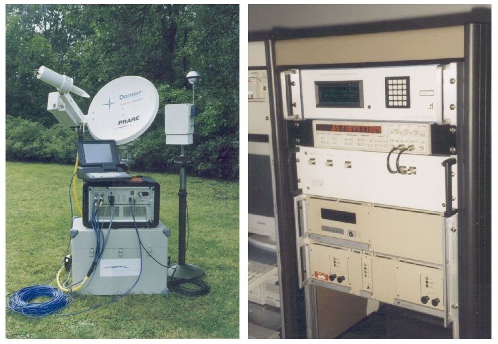
Precise Range And Range-Rate Equipment (PRARE)
The PRARE-system (Precise Range And Range-Rate Equipment) was developed in Germany in the eighties to measure distances and relative velocities between special PRARE ground stations and PRARE space segments on various satellites. By means of these measurements it is possible to determine the satellites orbits and coordinates of the PRARE ground stations very precisely. The PRARE measurement principle (determination of signal travel times and frequency Doppler shifting) is basically very similar to those of the US GPS-system or the French DORIS-system. Compared with GPS and DORIS, PRARE allows, being designed as a two frequency two way system, a more direct monitoring of parameters being relevant for the system accuracy (e.g., clock parameters and system-internal signal travel times).
A globally distributes network of PRARE ground stations (development at DORNIER, resp. ND-Satcom) was installed and operated on behalf of ESA (European Space Agency), tracking the satellites ERS-1 (1991), Meteor 3-7 (1994-1995) and ERS-2 (1995-2007) (space segments by Timetech resp. Kayser Threde). After the foundation of the GFZ and direction of department 1 by Prof. Dr. Dr. h.c. Reigber (formerly Deutsches Geodätisches Forschungsinstitut, DGFI), it was GFZ Section 1.2 being responsible for the system operation and PRARE product provision since 1992 (formerly DGFI). The operation of the PRARE-system was ceased in January 2007, mainly due to ground station aging and cost reasons (no funding since 2004).
A system operation report (until end of funding in 2003, in German language) can be found here.
Falck, C., Flechtner, F., Massmann, F.-H., Raimondo, J.-C., Reigber, Ch., and Scherbatschenko, A. (2013), Betrieb des PRARE-Bodensegments für ERS-2 - Abschlussbericht 2003. Scientific Technical Report 04/20, GFZ German Research Centre for Geosciences.
European Gravity Service for Improved Emergency Management (EGSIEM)

A new service for gravity field products and for forecasting and mapping of hydrological extreme events will be developed and implemented between 2015 and 2017 within the Horizon2020 Framework Program for Research and Innovation. Major contributions will be provided by GFZ´s Sections 1.2 “Global Geomonitoring and Gravity Field” and 5.4 “Hydrology”. Overall project lead is by the Astronomical Institute of the University Bern (CH), other contributing partners are the German Aerospace Center (D), University Graz (A), University Luxembourg (LUX), University Hannover (D), CNES (F) and Géode & Cie (F).
The overall objectives of EGSIEM are a) to deliver the best time-variable gravity products for applications in Earth and environmental science research, b) to reduce the latency and to increase the temporal resolution of the gravity and related mass redistribution products, and c) to develop gravity-based indicators for extreme hydrological events and demonstrate their value for flood and drought forecasting and monitoring services. This shall be done at different lead times (several months to near real time) via assimilation into flood forecasting models or in statistical forecasting approaches. An operational test run of at least half a year is foreseen in the frame of DLR’s Center for Satellite Based Crisis Information.
Primary input to EGSIEM is the GRACE (Gravity Recovery and Climate Experiment, NASA-DLR, since 2002) and GRACE-FO (Follow-on, NASA-GFZ, due for launch early 2018) satellite mission data which are e.g. provided by GFZ in the frame of the US-D GRACE Science Data Systems. These data will be complemented by satellite altimetry, GNSS (Global Navigation Satellite System) or SAR (Synthetic Aperture Radar) derived information.
Further information on the project background and status can be found here.
Simulation of the Global Geodetic Observing System (GGOS-SIM)
GGOS-SIM is a joint project with the Technische Universität Berlin (TUB) that aims at providing a tool for assessing and improving the quality of the International Terrestrial Reference Frame (ITRF). For this GGOS-SIM simulates the modern space geodetic techniques DORIS, GNSS, SLR, and VLBI, and the impact of new sites, co-locations, local ties, and technical improvements.
GGOS-SIM-2 is the follow-on project aiming at simulating the space geodetic techniques co-located in space on-board one satellite in order to assess the prospects for the TRF.
The master web site of GGOS-SIM is maintained at the TUB.