


The small satellite PRETTY (Passive REflectomeTry and DosimeTrY) was successfully launched from ESA's space center near Kourou in French Guiana on 9 October 2023 using a European VEGA rocket. In addition to two larger Earth observation satellites, Theos-2 (Thailand) and Triton (Taiwan), eight additional small satellites, known as CubeSats, were also successfully launched into a polar orbit around 565 kilometers above the Earth.
The GFZ is involved in the small satellite mission PRETTY (3U-CubeSat) as part of an ESA project within a scientific team together with the German Aerospace Center DLR, the Spanish space institute IEEC and the NTNU University Trondheim. PRETTY is equipped with a dedicated GNSS reflectometry receiver that can be used to determine the height of water and ice surfaces. The quality of such measurements from very small satellite platforms is to be tested for the first time in order to enable future cost-effective multi-satellite systems for Earth observation.
"Among other things, the satellite will carry out measurements for GNSS reflectometry, which will then provide us with very precise sea, glacier ice and wave heights." explains Prof. Jens Wickert, who is the main responsible for the mission at the GFZ. The dosimeters on board will also measure the radiation dose in space. This will be used to monitor space weather.
The PRETTY mission will provide many new insights: designed as a demonstrator mission, it will show what this type of small satellite and its compact sensors can potentially achieve. The main purpose of the reflectometer payload on board PRETTY is to demonstrate technical feasibility. These so-called CubeSats - satellites measuring only approx. 10x10x35 cm - are seen as an important option for the future of Earth observation, as they can carry GNSS technology and other small sensors for Earth observation on board as low-cost small satellites.
About GNSS reflectometry
The abbreviation GNSS stands for Global Navigation Satellite System. The term GNSS reflectometry (GNSS-R) summarizes various remote sensing methods in which signals reflected from water, ice or land surfaces are recorded and evaluated by navigation satellites. From this, important geophysical properties of these surfaces can be derived, such as the geometric height, soil moisture or roughness, which in turn allows conclusions to be drawn about the wind speed and direction over water surfaces. The spectrum of applications is very diverse and ranges from weather forecasting to climate research.
Data evaluation also with Artificial Intelligence (AI)
The technical subsystems of the satellite are currently being extensively tested using the first data received by PRETTY. The scientific GNSS reflectometry measurements are being prepared and the first experiments will be carried out towards the end of the year.
Analyzing data from small satellites is a challenge, as these platforms have limited technical capabilities compared to larger satellites. Nevertheless, geophysical observations of the highest possible quality should be carried out. Artificial intelligence methods are also used to analyze the data optimally. Dr. Milad Asgarimehr from the GFZ and TU Berlin is part of the PRETTY team and is responsible for the development of AI systems for data evaluation. He is the leader of the Helmholtz AI project "AI4GNSS-R" to develop new AI methods for GNSS-based Earth observation using the GNSS reflectometry method, also utilizing data from other satellites such as the U.S. CYGNSS multi-satellite mission.
AI4GNSS-R aims to implement deep learning for novel remote sensing data products based on spaceborne GNSS-R measurements. This includes, for example, high-quality data on wind speed at the sea surface, especially in extreme wind conditions such as hurricanes, and also precipitation over calmer oceans, which can also be measured with GNSS signals.
Further technical details:
- Flight: Flight VV23 - 8 October - Golden Horizon | THEOS-2 & FORMOSAT-7R/TRITON | Vega Launch | Arianespace; live stream of the launch on 9.10.2023 https://www.youtube.com/watch?v=XknbyH6ipxc
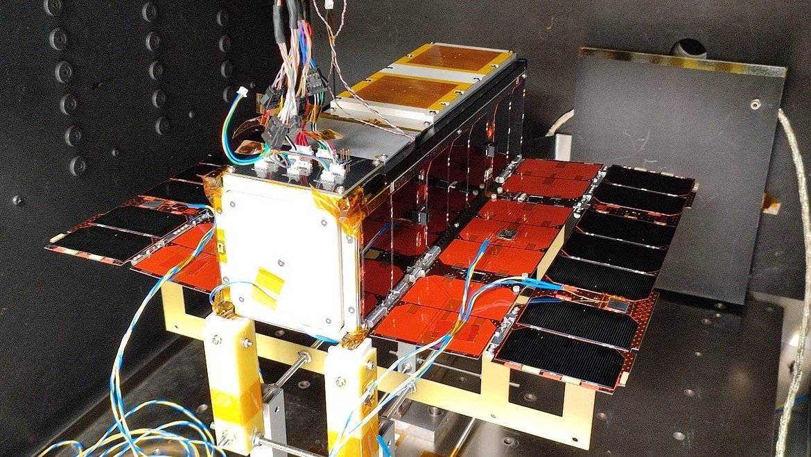
- Size: The PRETTY small satellite measures 10 cm × 10 cm × 34.05 cm.
- Energy supply: The fold-out solar panels each have a surface area of 30x20 centimeters and supply the satellite with an average power of 24 watts.
- Mass and orbit: 4.6 kilograms, polar orbit with an altitude of 565 kilometers.
- Data rate: PRETTY communicates at data rates of up to 2 Mbit/s; the satellite is operated from a ground station at Graz University of Technology.
- PRETTY was developed by Beyond Gravity Austria (concept and software system) in cooperation with ES, Seibersdorf Laboratories (dosimeter) and TU Graz (satellite bus). GFZ is part of an international scientific consortium (PRETTY-Science) for the evaluation of the GNSS reflectometry data and is contractually involved in the project.
- Duration: The mission is scheduled to last at least one year. At the end of the mission, PRETTY will naturally re-enter the Earth's atmosphere and burn up. Analyses show that this will occur after 25 years at the latest. The satellite complies with ESA and UN guidelines for minimizing space debris.
Sources:
- Unter Brücken und im Weltraum – Die neue Ära der GNSS-Reflektometrie passt in einen Schuhkarton Martin Bünnagel. Geodäsie im FOKUS. | zfv 1/2023 148. https://geodaesie.info/images/zfv/148-jahrgang-2023/downloads/zfv_2023_1_Geodaesie_im_FOKUS.pdf
- TU GRAZ: https://www.tugraz.at/institute/iks/weltraummissionen/pretty/mission
- https://www.esa.int/ESA_Multimedia/Images/2021/09/PRETTY_CubeSat
- https://www.gfz-potsdam.de/en/section/space-geodetic-techniques/topics/gnss-reflectometry


![[Translate to English:] Hörsaal](/fileadmin/_processed_/e/6/csm_H%C3%B6rsal_f1d7c412b9.webp "[Translate to English:]")


